The Concession Blocks are situated within a volcanic polymetallic metallogenic belt in Ciletah Bay, West Java, Indonesia, containing Gold (“Au”), Lead (“Pb”), Zinc (“Zn”) and Copper (“Cu”). Tectonically it is located at the southern margin of Sundaland, which is the continental core of southeast (“SE”) Asia formed by the accretion of blocks to the Eurasian margin (Figure 1). The belt is formed mainly of volcanic breccias and mostly covered by Quaternary eluvium and alluvium up to 20 m thick. Volcanic breccias, tuffs, and andesite are widely distributed in the Concession Blocks.

Figure 1: Geological Setting and Mineralised Zones, Ciemas Gold Project
Two (2) sets of faults are developed, striking to the northeast and northwest with extensions varying from about 100 m to 1,000 m; the faulting belts are generally 1 m to 20 m wide. These faults are the primary structures controlling the mineralisation and mineralisation-bearing zones in this area. Structural analysis indicates that the mineralisation-bearing faults represent three stages of tectonic activity.
Early activity in the extensional faults is shown by stockworks and structure filling mineralisation.
The middle stage activity is indicated by compressional faults with shear zones consisting of tectonic shears and fracture breccias, and Late activity represented by extensional faults with goldbearing fractured zones with chalcedony–quartz veins, silicification, pyritisation, and carbonization.
All of these styles of mineralisation are represented in the Ciemas Gold Project.
The structures in the Ciemas Gold Project are consistent with the regional structures, and are dominated by NE and NW faults and/or fractures. Within these structure zones, chalcedony-quartz veins are intermingled, often showing boudinage along strike and down dip.
The gold mineralisation at the Ciemas Gold Project is related to different fault stages of dominant structures and tension zones. These structure zones could be secondary fractures related to the Sumendala fault. The dacite (usually described as quartz-dacite porphyry) intrusion also provides favourable geological conditions for mineralisation.
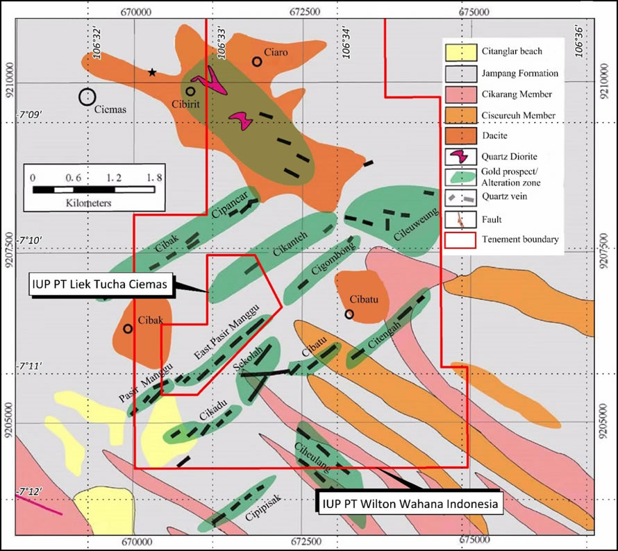
About 10 main gold mineralised zones have been defined by the exploration conducted in the Ciemas Gold Project area within an area of approximately 10 km2 in the central part of the Company’s tenement. A simplified geological map for the major mineralised zones defined in the Project is shown in Figure 2.

Figure 2: Distribution of Main Mineralised Zones of Ciemas Gold Project
Most gold mineralised bodies present in the northeast zone containing brecciated chalcedony- quartz carrying pyrite, arsenopyrite, and small amount of galena and sphalerite mineralization. The zone is covered by strongly silicified clay several metres wide containing disseminated pyrite. The indistinct external porphyritic alternation envelope features chlorite and scattered pyrite.
The Pasir Manggu Deposit is made up of three (3) sets of quartz veins from southwest to northeast which occur in andesitic lava and andesitic pyroclastic rock. It generally strikes to the northeast at 45° and dips southeast at 75° – 80°. Pasir Manggu West, located at the south- western most end of Pasir Manggu, was explored by drill holes on 20 × 20 m and 40 × 40 m grids, which delineated a mineralised belt with four major veins extending about 600 m along the strike in accordance with the tectonic framework.
According to the drilling findings, the gold mineralised veins are still open at depth and the defined down-dip extension exceeds 120 m at most but with an average controlled depth of 50 m to 70 m. The true thickness of gold veins in Pasir Manggu West varies from 1 m or less up to 10 m, with average thickness of about 4 m. The average grade of gold mineralised veins at Pasir Manggu West is about 7 g/t of Au.
Cikadu is composed of two (2) main mineralised bodies on a northwest strike and dip of 60° to75°, with a length of 700 m, a thickness of 1 m to 10 m, and an average Au grade of about 9 g/t.
Cibatu and Sekolah comprises 11 mineralised bodies plunging northwest and dipping 60° to 75°, including five (5) main bodies striking for a total length of 1,500 m, 1 m to 10 m thick, and with an average Au grade of about 9 g/t.
The structure and type of alternation in the northwest belt are similar to those found in the northeastern belt, but the northwest belt contains small amounts of chalcopyrite, and more galena and sphalerite. This zone mainly occurs in the Ciaro region. There are several northwest veins in the east which have been subject to extensive mining in the past. There are several north-south striking zones in various locations, but due to insufficient exploration works, their mineral bearing potentials are unknown. Several veins around Pasir Manggu strike approximately east-west, and are regarded as related to the northwest zone.
There are few outcrops of intrusive rocks; quartz porphyry outcrops are observed in the Cileuweung block. Potential for further discoveries of numerous gold occurrences are scattered throughout the Ciemas Gold Project. The primary mineral commodity is the gold ore.
Three (3) types of gold mineralisation were distinguished and can be described as:
- Quartz vein type – Pasir Manggu, Cigombong, Cileuweung, Cibak, and Cipancar Prospects.
- Structurally controlled alteration / tectonically altered-rock type – Cikadu, Sekolah, Cibatu, Ciheulang, and Japudali Prospects.
- Quartz porphyry intrusive type – Cipirit, Ciaro and Cibuluh Prospects


